
Summary
The Washington State floods represent a significant and recurrent natural hazard impacting communities, infrastructure, and ecosystems across the region. Characterized by frequent and severe flood events driven largely by atmospheric river systems, these floods have caused widespread property damage, economic disruption, and threats to public safety throughout the state’s history, from notable 19th-century inundations to catastrophic events in recent decades. The interplay of Washington’s diverse geography—including low-lying river deltas, mountainous snowpack regions, and vulnerable coastal areas—with changing climate patterns has intensified flood risks, making flood management a critical statewide priority.
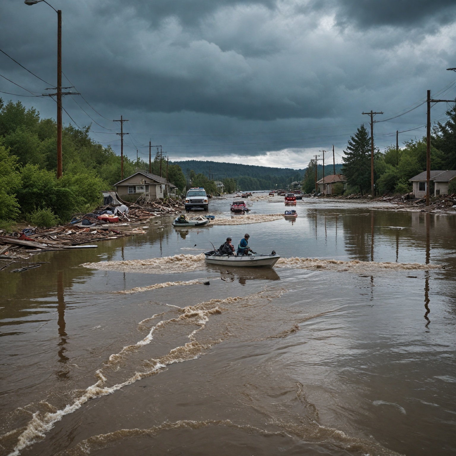
Notably, the 2025 floods marked one of the most devastating episodes in recent history, leading to the evacuation of tens of thousands of residents, severe damage to transportation networks, thousands of homes affected, and over $500 million CAD in estimated economic losses. While no fatalities were reported during this event, emergency responders conducted extensive water rescues amid record-breaking river levels and widespread landslides. These floods also exacerbated environmental challenges by threatening key fish habitats and wetlands, which are vital to Washington’s commercial, recreational, and tribal fisheries.
Washington’s response to flooding involves coordinated efforts among state, local, tribal, and federal agencies focusing on emergency management, infrastructure resilience, and community preparedness. Recent legislative changes and funding initiatives, including Senate Bill 5649 and programs like Building Resilient Infrastructure and Communities (BRIC), aim to enhance pre-disaster mitigation and improve floodplain management. Despite these efforts, significant challenges remain in addressing infrastructure vulnerabilities and adapting to the increasing frequency and severity of floods driven by climate change.
This ongoing crisis highlights the need for comprehensive strategies that integrate ecological restoration, urban planning, and emergency response to reduce flood hazards and support recovery. The Washington State floods underscore the broader implications of climate-induced natural disasters, illustrating both the urgent necessity and complexity of building resilient communities in a changing environment.
Historical Background
Flooding in Washington State has been a recurring and significant challenge since at least the late 19th century. Historical newspaper archives from Skagit County document some of the earliest major flood events, such as the severe inundation of 1892, when floodwaters were so deep that small boats and rafts were necessary for navigating streets, forcing many residents to evacuate their homes for safety. Another notable early flood occurred in 1897, overwhelming levees near Mount Vernon’s lowest-lying areas and inundating parts of south Mount Vernon, which led to forced relocations. The Columbia River also experienced a catastrophic flood in June 1894, with a record crest that destroyed Fort Cascade and the town of Cascade, which was never rebuilt.
In more recent history, flooding events have continued to impact the region severely. For example, the February 1996 flood was one of the most widespread across the Pacific Northwest, affecting 24 of Washington’s 39 counties. This event was driven by a combination of record precipitation in mountainous areas and rapid snowmelt, producing extensive flooding, mudslides, and avalanches. The 1996 floods resulted in over 2,600 homes flooded, dozens of destroyed bridges, an estimated $120 million in damages, and three fatalities across the state.
The persistent threat of flooding has only intensified with time. Major floods have repeatedly struck communities in the same areas, including those affected in 2021 and again in subsequent years. Days of torrential rain have caused historic floods that stranded families on rooftops, washed over bridges, and damaged infrastructure, prompting large-scale evacuations, especially in agricultural regions north of Seattle along the Skagit River floodplain. These floods have caused significant disruptions, including stranded residents, destroyed homes, and compromised transportation routes.
Atmospheric river systems, which are common on the West Coast, have played a major role in the severity and frequency of flooding. These systems bring intense precipitation and have been linked to more than $1.1 billion in annual flood damage in Western states. Research suggests that climate change is influencing atmospheric rivers, making them more intense and frequent, which exacerbates flooding risks in Washington. The combination of rising temperatures and altered precipitation patterns is expected to further increase flood hazards, especially when coupled with other factors like snowmelt and saturated ground conditions.
These historical flood events have not only caused immediate damage to communities and infrastructure but have also posed ecological risks. The Skagit River basin, for example, is home to key fish species such as Chinook and pink salmon, which are vulnerable to flooding due to their spawning behaviors. Severe flooding threatens these populations and, by extension, the commercial, recreational, and tribal fisheries that depend on them.
Geographic and Environmental Context
Washington State’s diverse geography and environmental conditions significantly influence the patterns and impacts of flooding across the region. The state features a complex landscape that includes coastal areas, river deltas, mountainous terrains, and extensive wetlands, all of which interact with climatic factors to shape flood dynamics.
The western portion of Washington, particularly areas such as the Skagit River Delta and Willapa Bay, is especially vulnerable to flooding due to its low-lying topography and proximity to Puget Sound. These regions serve as critical zones where flooding has repeatedly caused severe disruption to communities, infrastructure, and the economy, notably affecting shipping terminals, marinas, docks, and recreational facilities integral to the coastal port districts. The Skagit River, flowing from the Cascade Range through fertile farmland before reaching Puget Sound, is a focal point for flood concerns; historic flood levels have been recorded in towns like Burlington and Sedro-Woolley, with water levels surpassing all previous records during recent events.
The Cascade Mountains play a vital role in Washington’s hydrology. Snowpack accumulation in these high-altitude regions typically acts as a natural reservoir, releasing meltwater gradually during warmer months. However, climate change is altering this balance by reducing snowfall and increasing rain-on-snow events, leading to more immediate runoff and higher flood risks downstream. The diminished snowpack in mid to high elevation zones exacerbates flooding potential by increasing streamflow variability and reducing flood control opportunities in headwaters. Rapid snowmelt combined with heavy rainfall has historically contributed to significant flooding and associated hazards such as mudslides and avalanches throughout the region.
Wetlands across Washington are another critical environmental feature impacted by changing flood patterns. These ecosystems serve as natural buffers, absorbing excess water and mitigating flood impacts. Unfortunately, many wetlands face threats from flooding, drying, or relocation due to shifts in precipitation patterns and rising temperatures, leading to habitat loss and increased vulnerability for native fish species and other wildlife. Freshwater habitats in mid to high elevation areas are particularly at risk, with increased stream temperatures and invasive species further stressing native fish populations vital to commercial, recreational, and tribal fisheries.
Atmospheric river events are a key driver of Washington’s precipitation and flooding. These narrow corridors of concentrated moisture transport can produce intense rainfall, often leading to extreme flood events. Research indicates that atmospheric rivers account for the majority of flood damage on the West Coast, with climate change intensifying these phenomena by increasing the amount of precipitation they deliver, thereby raising the frequency and severity of floods. The interplay of atmospheric rivers with the state’s geography, including mountainous and urban areas, often results in significant urban and riverine flooding, landslides, and infrastructure damage.
Impact of Floods
The 2025 Washington State floods caused widespread devastation across large parts of the state, severely impacting infrastructure, communities, and the economy. Numerous bridges were flooded, and major roads were either inundated or washed out, significantly disrupting transportation networks. The severity of the flooding led to the evacuation of over 44,000 residents, with some communities such as Burlington and areas within the Skagit River floodplain receiving urgent “go now” evacuation orders to ensure public safety.
Effects on Communities and Infrastructure
Entire neighborhoods were submerged underwater, with surveys reporting nearly 500 residences destroyed or severely damaged and over 2,300 needing repairs. The flooding and associated landslides—numbering more than 1,500 across the state—caused blockages on highways and damaged roads and bridges, hampering emergency response and recovery efforts. Local authorities and emergency responders carried out numerous water rescues to protect residents from the life-threatening conditions created by the record-breaking floods. Despite the scale of the disaster, there were no reported fatalities, though officials warned of the potentially lethal nature of the event.
Economic and Business Impact
The floods inflicted extensive economic damage, with estimates of losses exceeding $500 million CAD due to infrastructure damage and disrupted supply chains. Hundreds of local businesses halted operations, facing broken supply lines and challenges in logistics, which raised concerns about the long-term financial repercussions for the region’s economy. The agriculture sector, supply chain, transportation infrastructure, and the broader economy suffered significant adverse effects, underscoring vulnerabilities in the state’s disaster preparedness and resilience.
Environmental and Ecological Consequences
The flooding compounded ongoing environmental challenges in Washington, including impacts on freshwater fish habitats and wetland areas already threatened by climate change. Reduced snowpack and increased storm intensity have exacerbated habitat loss, particularly in mid to high elevation areas, affecting native fish populations and commercial fisheries. Coastal and port districts experienced amplified economic effects due to damage to shipping terminals, marinas, docks, and recreational facilities, illustrating how ecological disruptions translate into economic vulnerabilities.
Lessons and Future Directions
This disaster highlights critical gaps in infrastructure resilience, urban planning, and disaster response systems across the state. Addressing vulnerabilities such as levee systems, erosion threats, and flood control structures is essential to mitigate the impacts of future severe events. Furthermore, the floods have emphasized the need for improved coordination among counties, tribes, and local governments on evacuation, emergency protective measures, and recovery strategies. Investments in sustainable infrastructure and robust disaster recovery programs are vital to safeguard Washington’s economic future and enhance community resilience. Programs such as the Flood Mitigation Assistance Program aim to reduce future flood risks through acquisitions, building retrofits, and hazard mitigation planning, offering a pathway toward long-term recovery and adaptation.
As waters recede, affected residents are beginning to return to assess damages, marking the start of a challenging recovery phase that requires continued support and strategic planning to build a safer, more adaptable environment in Washington State.
Flood Management and Prevention
Washington State faces recurrent flooding challenges, with many communities experiencing devastating floods multiple times within a few years, such as in 2021 and more recently. To address these risks, county, local, and tribal governments actively respond during flood events, often relying on assistance from organizations like the Washington Conservation Corps (WCC), which helps clear debris, operate pumps, and manage sandbagging efforts to mitigate immediate impacts.
Preventing flood damage is a critical priority, as cleanup costs after floods can be three times higher than proactive prevention measures. The state provides resources to communities to identify flood hazards, design flood-resilient landscapes, and implement projects that reduce risks to life and property. These efforts involve partnerships among local governments, state and federal agencies, and private organizations to coordinate multi-benefit floodplain management projects that restore natural floodplain functions while reducing hazards.
Key infrastructure vulnerabilities remain a focus, with critical levee systems, erosion threats, and flood control structures at risk of failure during severe events. Active projects across the state include levee rehabilitation in King County and addressing erosion threats in Skagit and Snohomish counties. Coordination among federal, state, and local agencies ensures preparedness efforts such as evacuation planning and emergency protective measures are aligned to safeguard communities.
Recent legislative action, notably the passage of Senate Bill 5649 in 2024, amended state floodplain management laws to allow substantial improvements and alterations to homes located within floodways, aiming to make them safer and more flood-resistant. To implement these changes, Washington is expediting amendments to floodplain management rules, allowing communities to request floodplain waivers for projects that proactively reduce flood damage. This rulemaking enhances public safety and reduces disaster costs by promoting pre-disaster mitigation.
Financial support for flood risk reduction is provided through several programs. The Flood Control Assistance Account Program is a primary funding source for floodplain management planning and emergency assistance to local jurisdictions. Additionally, the Building Resilient Infrastructure and Communities (BRIC) program funds projects focused on reducing flood risks before disasters occur, including infrastructure upgrades and nature-based solutions. Floodplains by Design, a public-private partnership, aims to improve floodplain resiliency by integrating flood mitigation with habitat restoration. These funding sources are administered by the Department of Ecology in coordination with federal programs such as FEMA’s Hazard Mitigation Assistance grants.
Community preparedness and public engagement are vital components of flood management. The Washington Emergency Management Division leads statewide mitigation, preparedness, response, and recovery efforts to minimize disaster impacts on people, property, and the economy. Public alert systems and evacuation planning tools help residents stay informed and ready to respond to flood threats. Volunteer and community organizations provide critical support for recovery, including food distribution, shelter assistance, and financial aid to affected residents.
Emergency Response and Recovery
In response to the severe flooding in Washington State, Governor Bob Ferguson declared a statewide emergency and requested an expedited emergency declaration from the federal government to unlock critical resources and funding for recovery efforts. This declaration enables the Federal Emergency Management Agency (FEMA) to provide federal assistance and equipment, covering 75% of related costs, while the state mobilizes its emergency operations at the highest activation level to coordinate response activities.
The Washington National Guard has been activated and placed on standby to support response efforts alongside state emergency management teams, which maintain constant communication with local governments, tribal entities, federal partners, and the National Weather Service to monitor evolving conditions and ensure coordinated action. Evacuation orders have been issued for tens of thousands of residents, particularly in flood-prone areas such as the Skagit River floodplain, and authorities strongly urge compliance with these directives to protect lives.
Emergency shelters and essential services are being provided through organizations such as the American Red Cross, which has deployed teams on the ground to assist displaced residents and deliver immediate support in flood-affected communities. Other local entities like the Salvation Army and community action agencies are also actively involved in relief efforts, offering food distribution, shelter support, and recovery services. Fundraising and volunteer initiatives, including those organized by the Twin Sisters Mobile Market and local foundations, are helping to bolster these efforts by channeling resources directly to affected families and neighborhoods.
The Washington Emergency Operations Center (EOC) serves as the central hub for disaster information gathering, response coordination, and collaboration among state agencies, federal representatives, and volunteer organizations. The EOC’s Level 1 activation reflects the gravity of the situation and underscores the continuous work to analyze damages, deploy resources, and strategize recovery actions.
Long-term recovery plans include addressing infrastructure vulnerabilities such as levee rehabilitation and flood control projects to mitigate future risks. The U.S. Army Corps of Engineers, FEMA, and the Washington Emergency Management Division are collaborating closely with local governments and tribal partners to improve preparedness and resilience through programs focused on floodplain management, permitting, and environmental compliance. These efforts emphasize accurate damage reporting, effective evacuation planning, and coordinated disaster assistance to facilitate rebuilding while reducing the likelihood of similar devastation in future flood events.
For residents facing ongoing challenges, numerous state and federal programs offer support including temporary housing assistance, home repair aid, disaster unemployment benefits, and low-interest loans for individuals and businesses impacted by the floods. Additionally, crisis intervention resources such as the 988 Suicide and Crisis Lifeline, Washington State Crisis Connections, and the American Red Cross Disaster Mental Health Support are available to provide emotional and psychological support to those affected.
Despite tireless efforts by emergency responders conducting water rescues and providing relief, the scale of destruction remains significant, with entire neighborhoods submerged, highways blocked by landslides and debris, and critical infrastructure damaged or destroyed. The ongoing situation highlights the urgent need for enhanced urban planning
Essential Resources for Residents
Residents affected by the Washington state floods have access to a variety of resources designed to provide immediate support, recovery assistance, and ongoing help throughout the disaster response and rebuilding process. For those displaced or in urgent need, the American Red Cross – Washington Flood Support offers emergency shelter, preparedness and evacuation planning tools, sandbag locations, and flood response updates on the ground in affected communities. Local emergency management agencies in counties such as Whatcom and Snohomish provide flood alerts, evacuation guidance, and recovery resources tailored to their respective areas.
State and federal programs are available to assist residents in recovering from flood-related losses, including temporary housing assistance, home repair aid, disaster unemployment support, and low-interest loans for individuals and small businesses. The Disaster Cash Assistance Program (DCAP) offers financial aid to those impacted by the floods, helping to alleviate immediate economic hardships. For technical support and long-term flood hazard mitigation, programs like the Building Resilient Infrastructure and Communities Program (BRIC) and the Flood Control Assistance Account Program provide grants and resources to local and Tribal governments for floodplain management, public infrastructure projects, and adoption of modern building codes to reduce future flood risks.
In addition to physical and financial assistance, emotional and mental health support is a crucial component of recovery. The 988 Suicide and Crisis Lifeline offers free, confidential support 24/7 by phone, text, or online chat, while Washington State Crisis Connections provides local crisis intervention and emotional support services. The American Red Cross also delivers disaster mental health support to connect residents with additional resources and aid their psychological recovery.
To help residents navigate post-disaster housing challenges such as mortgage delinquency, foreclosure mediation, property taxes, and homeowners association fees, the Washington State Homeownership Hotline is available at 877-894-4663, where counselors provide guidance and support. Furthermore, health safety tips for flood cleanup are offered by the Department of Health to minimize health risks during recovery efforts.
Residents are urged to comply with evacuation orders to ensure their safety and stay informed through official alert systems such as the Washington Integrated Public Alert & Warning System, which is managed by the Washington Emergency Management Division to coordinate mitigation, preparedness, response, and recovery efforts across the state. Following these guidelines and utilizing available resources can significantly aid individuals and communities in navigating the challenges posed by the floods.
Case Studies of Notable Flood Events
Washington State has experienced numerous significant flood events throughout its history, many of which have had profound impacts on communities, infrastructure, and the economy.
One of the earliest documented floods occurred in 1892, when heavy flooding in the region led to streets being navigable only by small boats and rafts, forcing many residents to evacuate their homes for safety. This event was followed by another major flood in 1897, which overwhelmed levees near Mount Vernon’s lowest areas, inundating parts of south Mount Vernon and prompting relocations. These early events highlighted the vulnerability of the region prior to the implementation of modern flood control measures.
More recently, in November 2006, Western Washington faced one of its wettest periods on record, triggered by a strong, warm, and wet Pacific weather system from November 2 to 7. This event caused the highest flood levels ever recorded on several southwest Washington rivers, including the Chehalis, Skookumchuck, and Nisqually. The flooding led to the evacuation of over 44,000 people and triggered more than 1,500 landslides across the state, resulting in damages exceeding $72 million. Urban and small stream flooding was widespread, affecting counties such as Snohomish, King, Lewis, Thurston, Mason, and Kitsap, with rainfall totals ranging from 3 to 8 inches.
In December 2025, torrential rain caused historic flooding in Western Washington, with rivers reaching record levels that stranded families on rooftops and washed over bridges. The Skagit River floodplain, home to a major agricultural region north of Seattle, was severely impacted, prompting evacuation orders for about 78,000 residents. Several homes were ripped from their foundations, and extensive damage to infrastructure was reported. Despite no fatalities, authorities warned of the potentially lethal nature of the flooding and emphasized the severity of the situation as historic in scale. Notably, some communities affected had also faced significant flooding just four years earlier, underscoring the recurrence and increasing intensity of flood events in the region.
Atmospheric river systems are frequently identified as primary drivers behind these major precipitation and flooding events along the West Coast. Research indicates that these systems account for approximately 84% of flood damage in Western states, causing over $1.1 billion in annual damage on average. Climate change is believed to be influencing the frequency and intensity of atmospheric rivers, contributing to more extreme storms and heavier rainfall, which exacerbate flooding risks in Washington.
These case studies demonstrate the ongoing challenges Washington faces in managing flood risk, with historic events providing valuable lessons for improving infrastructure, emergency response, and community resilience to better prepare for future floods.
Future Outlook
Washington State faces a complex and evolving future regarding flood risk as climate change continues to alter environmental conditions. Rising temperatures are intensifying factors that contribute to flooding, such as increased storm surges, rapid snowmelt, and atmospheric rivers, leading to more frequent and severe inland and coastal floods. Coastal areas are particularly vulnerable, with rising sea levels causing earlier and more intense impacts, including accelerated beach erosion and higher wave intensity along the coastline. In Eastern Washington and the Cascades, spring snowmelt combined with rain-on-snow events remains a major source of flood risk, alongside other hazards like flash floods and ice jams.
To address these challenges, Washington has developed comprehensive climate adaptation and flood management plans that provide a roadmap for responding to extreme climate impacts such as wildfires, severe heat, drought, and flooding. These plans emphasize coordinated efforts among local governments, state and federal agencies, and private organizations to implement multi-benefit projects that reduce flood hazards while restoring natural floodplain functions. Programs like the Flood Control Assistance Account and Floodplains by Design enable communities to access funding for floodplain management, hazard mitigation planning, and infrastructure improvements that incorporate nature-based solutions. The Building Resilient Infrastructure and Communities Program (BRIC) further supports proactive investments in flood risk reduction before disasters occur.
Infrastructure resilience remains a critical concern, with ongoing vulnerabilities in levee systems, erosion-prone areas, and flood control structures requiring attention to prevent failure during severe events. The state is also updating floodplain management rules to improve public safety by allowing communities to pursue floodplain waivers for projects that reduce flood damage preemptively. Moreover, partnerships with federal programs such as FEMA’s Risk MAP provide enhanced data, risk assessments, and mitigation expertise to better prepare local and Tribal governments.
The economic and social impacts of flooding underscore the importance of sustained investment in resilient infrastructure and emergency response frameworks. Strong policy interventions and community preparedness efforts will be key drivers in mitigating future losses and supporting recovery. Efforts to integrate flood risk considerations into urban planning, shoreline management, and habitat restoration continue to be priorities to ensure sustainable development and protect vulnerable ecosystems. By leveraging federal funding opportunities from initiatives like the Bipartisan Infrastructure Law and the Inflation Reduction Act, Washington aims to enhance its adaptive capacity and secure long-term resilience against the growing threat of floods.
The content is provided by Sierra Knightley, Brick By Brick News